Free download HoudahGeo

HoudahGeo

4.0.1
One-stop photo geocoding for the Mac: Know where you took that photo
Free Download
User rating
5/10
8 votes
License
Shareware
OS
Windows
Version
4.0.1
Language
English
Release date
19 February 2015

Editor's review

This tool helps to geotag photos.

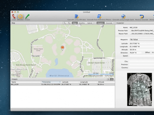
HoudahGeo is a photo geocoding & geotagging solution. It works on the Mac OS X platform. It helps add location lat-long information to the photograph taken. Geo-tagging helps keep the geographic location information along with the photo. Even if you do not remember later, where the particular shot was taken; the photos now carry that information for ever. HoudahGeo can store latitude, longitude and altitude information right within the image file. The data will be invisible and complete. It is able to write into all the industry standard photo files like the EXIF, XMP and IPTC tags. This tool is tightly integrated with Apple iPhoto and Aperture. It also allows for direct access to your Adobe Lightroom catalog. It can help you geotag using EXIF, XMP and IPTC tags for archival and let you publish your photos on Google Earth, Flickr, EveryTrail or locr.

You can publish GPS tracks and photos to Google Earth and be able to view it with eference to the exact location on the earth. While this is an additional and optional information for amateurs like you and me, professionals need to record this information on their photos. This tool really shines when documenting travel. Image a Safari, Animals roaming in the middle of nowhere, etc. By the end of the day, with the information recorded on the images taken, you are able to see a birds-eye view of your journey. You will be able to locate, exactly, the spot where you took the most memorable shot. It has the capability to match photos to GPS track logs and waypoints from GPX, NMEA, Sony LOG, Wintec TES, etc. files. It will be able to match photos to reference photos taken using iPhone. It can do the same with the built-in map and point to the desired location on Google earth. This is a very good tool.

Publisher's description

HoudahGeo: Know where you took that photo!
HoudahGeo is a one-stop photo geocoding and geotagging solution for Mac OS X.
Export geotags to EXIF, XMP and IPTC.
GPS device optional.
HoudahGeo 'pins' photos to locations where they were taken.
Professional grade processing. Mac ease of use.
HoudahGeo can store latitude, longitude, and altitude information right within the image file - invisibly, with no loss of quality.
HoudahGeo writes EXIF, XMP, and IPTC tags. JPEG, RAW or XMP files.
HoudahGeo projects may be published to EveryTrail or viewed and shared using Google Earth.
Geotagged photos may be saved to Evernote or uploaded to Flickr or locr.
* One-stop geocoding for the Mac
HoudahGeo caters to two very different needs:
- Geotagging for archival purposes using EXIF, XMP and IPTC tags
- Geocoding for publishing to Google Earth, Flickr, EveryTrail or locr
* GPS device: optional
HoudahGeo offers you many ways of geocoding your favorite photos:
- Automatic: Matches photos to GPS track logs and waypoints. GPX, NMEA, Sony LOG, Wintec TES, etc.
- iPhone / iPad: Matches photos to reference photos taken using iPhone
- Using a map: Pick locations using the built-in map
- Using Google Earth: Point to the desired location
- Precision: Attach photos to GPS waypoints
- Manual: Enter coordinates found on Google Earth, Wikipedia, etc.
* GPS device: supported
HoudahGeo connects directly to many brands and models of GPS track loggers.
It also reads GPX, NMEA, LOG, TES, ... and TCX files created by third party software.
HoudahGeo
HoudahGeo
Version 4.0.1
Free Download

User comments

Rate this program